Safety is a huge concern in a freezing climate. Everyone that comes to McMurdo must go through a 2 day safety course called Snowcraft I. Here it is commonly called Happy Camper School because the most noteworthy thing you do is camp outside when temperatures are extreme. For me, the experience began at 8am on Tuesday. 20 students including myself started the day in the classroom learning about important things like how to stay happy and warm as well as typical first aid concerns like hypothermia and frostbite. I didn’t realize exactly how much your nutrition and hydration had to do with your well being out there- for example if you aren’t drinking enough water, your blood vessels and other tissue constrict in order to make a smaller volume of water go further. For tiny vessels in our extremities, this severely limits circulation and is a major cause of frostbite and hypothermia. After our morning lecture, our instructors Susan and Matt drove us out onto the snow covered ice shelf 5 miles or so away from McMurdo. In case you’re interested, there is an important difference between sea ice and an ice shelf: sea ice is seasonal or semi seasonal ice that freezes straight out of the ocean water and is usually 3-4 meters thick; an ice shelf is glacially derived ice that is "permanent" and usually 200-300 feet thick. After this was explained to me, I felt much more comfortable jumping and digging and driving on the ice shelf, even though it looks more like a flat white plain than an ice shelf.
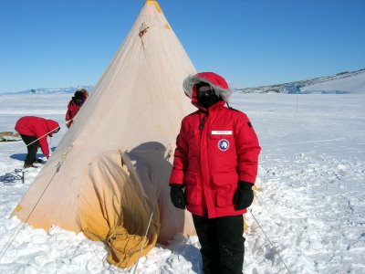
Me in all my cold weather gear standing by our Scott tent
We spent the rest of the day learning how to survive in emergency situations, how to cook on a camp stove, and how to set up a Scott tent (see above). By far the coolest part of the day was building our quinzee (snow hut or cave) and ice block walls. A quinzee is basically an igloo but not made out of ice blocks- the living space is just carved out from a big pile of snow. As a group of 20, we spent about an hour piling snow and more than that for carving it out and making the entrance. I can’t imagine trying to build one by yourself! We also made a wind wall out of blocks cut out of the snow using saws. I spent the night in one of the quinzees...here's what I slept in/on: long underwear tops and bottoms, fleece pants, 2 pairs of socks, another midweight and heavy fleece, 2 neck gaitors and a hat, glove liners, a fleece sleeping bag liner, a -30 degree rated sleeping bag, 2 ensolite pads to insulate against the ground, and big red over my legs to top it all off (you can't really move a whole lot after that). I had one oval shaped window to the outside world over my mouth and nose. I actually slept pretty well, aside from the fact that my sleeping bag was a bit big and had some air pockets. That night definitely felt like a REAL Antarctic experience.
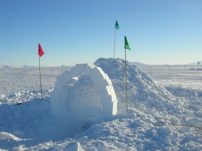 Our quinzee hut! We added the arch out of ice blocks as a fun technical challenge. Notice the fact that the entrance is below the ground surface- this is because you want the hot air you produce inside to stay inside! The lowered entrance serves as a cold air sink.
The next day we got to learn how to use the high frequency (HF) and very high frequency (VHF) radios. The HF radio is something you would see in a World War I movie. It is a huge box with wires that you stretch out in a V formation 40 feet long and then suspend them from bamboo sticks. For practice, I personally got to call the South Pole station (300 miles away) and ask their RadioOps person how cold it was (-42 C). That was pretty neat and took some getting used to. You have to yell uncomfortably loudly and use all the proper radio jargon (“over,” “clear,” etc). We ended the day by doing a white-out simulation. For this exercise, Susan and Matt handed out white 5 gallon buckets with faces drawn on them. We had to put them over our heads and rescue a pretend group member that had left the tent to go to the bathroom and couldn’t find their way back. In a whiteout, there are usually winds of 80 miles per hour or more, so you can’t hear anything either. So we couldn’t see or hear or talk…needless to say my group didn’t do so well but it was a great demonstration of how difficult the actual conditions can be!

Whiteout simulation
 Santa disembarking from his updated sleigh


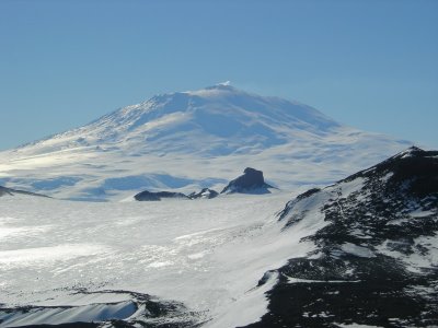
 Antarctica isn't all ice...although I do appreciate the glaciers.

 Half of Lake Hoare Camp (Canada glacier in the background)
 The Taylor Valley (Lake Hoare in the foreground)
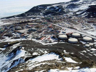 View of McMurdo Station from Observation Hill

