Monday, November 27, 2006

Stream Gauges

Ray and I are settled in to F6 camp- Lee is on her way soon. We’ll spend a lot of time here because 11 of the 19 streams we monitor are in this basin. The streams are not flowing yet, so we are just spending our time opening the stream gauges in preparation for the coming of the meltwater.


Stream gauge on Delta Stream (snowed in)

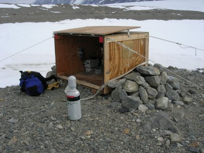
Lost Seal stream control structure- dam and flume

Each stream gauge is contained in a large plywood box that is secured to the ground with rope tie-downs. When I talk about a ‘stream gauge,’ I mean the box and everything that is contained within it- explanations to follow. The stream gauge is located on the shore of the stream, next to what hydrologists call a control structure. The control structure is located within the stream flow channel and usually consists of sandbags and tarps that direct all of the flow to one aperture in the wall, in this case a flume. The flume is an hourglass shaped channel with a staff plate that you can read to tell you the height of the water, or stage. What we are interested in though, is not the stage, it is the volume of water per time, or discharge. Saying “the water was flowing at a height of 1.3 feet” tells us a lot less than “the discharge of the stream was 4 cubic feet per second.” Hydrologists use a mathematical relationship called a rating curve to relate stage and discharge. Every time we visit a stream, we manually measure the stream discharge (future post about how we do this) and read the staff gauge to get the stage. This stream visit will give us one point on the rating curve, a plot with discharge on the X-axis and stage on the Y-axis. Enough visits to the stream and we have enough points on our rating curve to have a clear picture of the stage-discharge relationship in that particular stream (it will be some sort of readable relationship, not just a cloud of dots). Therefore next time we go to the stream, we can just read the staff plate because using our graph, we can figure out what the discharge is.

Example of a rating curve from www.geologyeducation.com

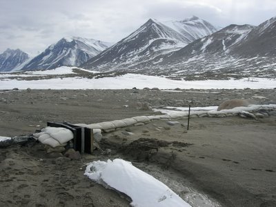
The reason we have a gauge box is to help us measure stream parameters more often than whenever we have time to hike out to the stream. We have the stream gauge set up to take readings once every 15 minutes- 96 readings per day! Inside the gauge box are instruments that measure three things about the stream: stage, water temperature, and specific conductance. There are two wires and one small tube that run from the gauge box to the bottom of the flume. To measure stage, a tiny bubble of compressed nitrogen gas is sent through the tube and an instrument in the gauge box measures the pressure required to emit this bubble, essentially measuring the height of water (or stage) above where the bubble comes out. Convert all these stage measurements to discharge using our rating curve, and we have 96 discharge measurements every day! The specific conductance sensor sends an electric pulse through the water and measures how fast it travels, telling us how much material is dissolved in the water. The temperature sensor is self-explanatory. Having 96 measurements a day really helps us elucidate the patterns of the stream and can help us figure out if something anomalous happens. Using all of our measurements from the first trickle of meltwater to the end of the summer melting season, we can also get a good idea of how much total water came through the system. This can be very helpful if the source for the stream is a glacier because then we have a good idea of how much it melted.

Thursday, November 23, 2006

The Dry Valleys

Half of Lake Hoare Camp (Canada glacier in the background)

I have finally arrived at my field site, the place I will live and work until February. Our time will be split between Lake Hoare Camp (where I am now) and F6 camp on Lake Fryxell. Lake Hoare Camp is a pretty posh field camp as far as field camps go, and even has a camp manager who cooks dinner for us! We will make it to F6 in a few days. My field area of study (and both Lake Hoare Camp and F6 camp) is located in the Dry Valleys, a rare area ofrelatively ice free land that is effectively a cold desert. I will be working predominantly in the Taylor Valley, the southernmost dry valley.
The Taylor Valley (Lake Hoare in the foreground)
The dry valleys are so named because there is no snow or ice on the ground surface and there is extremely low air humidity (even lower than the rest of Antarctica). Weather systems that deliver anything but high winds are rare because of the protection provided by the Transantarctic Mountains and the direction of the prevailing winds. The winds in the valleys are also unique because even though they are coming off of the continental ice sheet, they can be very warm. Researchers have discovered that as the air descends into the valleys off of the ice sheet, it is compressed, the act of which releases heat. These warm winds and weather protection often make the dry valleys 10-15 degrees F warmer than McMurdo. Thank goodness!

Because of its stark and desolate landscape, scientists often compare this region to the surface of Mars. Instead of ice, loose gravelly material that comes from the end moraines of the valley glaciers makes up the substrate. This landscape is also unique because running water is very rare on the surface of Antarctica. Here, as summer temperatures rise to just above freezing and the 24 hour sunlight begins to melt the glaciers, streams start to run. It is this melting season that my group is interested in.

There are very few macroorganisms in the valleys, but a surprising amount of life is hidden in the streams and soils. Some examples of organisms are: stream algae, nematodes, moss, plankton, bacteria and other microorganisms called tardigrades and rotifers. In the winter, most of these organisms exist in a freeze-dried state calledanhydrobiosis. When the water begins to run in the summer months, they spring back to life within days or weeks.

The valleys are so sensitive to human impact that you can find footprints made by people 60 years ago. Earlier expeditions were careful, but often contaminated the land with trash or fuel. Science groups have dug up trash heaps from 1945 that still haven't decomposedat all. Modern environmental regulations were established to avoid contamination in an environment where any pollution would last for extremely long periods of time. Now, all fuel is delivered to the valleys in 55 gallon drums at the start of the season, and even aspill of a teaspoon has to be reported and cleaned up by the spill response team. All used water (even for washing hands) and human waste is put in barrels and flown out at the end of the season. The dry valleys were designated as an Antarctic Specially Managed Area in 2004. This designation means that scientists from the US, New Zealand and Italy as well as tourists work together toward stricter environmental standards established by the agreement.

View from my tent at Lake Hoare Camp

Saturday, November 18, 2006

Happy Camper School

Safety is a huge concern in a freezing climate. Everyone that comes to McMurdo must go through a 2 day safety course called Snowcraft I. Here it is commonly called Happy Camper School because the most noteworthy thing you do is camp outside when temperatures are extreme. For me, the experience began at 8am on Tuesday. 20 students including myself started the day in the classroom learning about important things like how to stay happy and warm as well as typical first aid concerns like hypothermia and frostbite. I didn’t realize exactly how much your nutrition and hydration had to do with your well being out there- for example if you aren’t drinking enough water, your blood vessels and other tissue constrict in order to make a smaller volume of water go further. For tiny vessels in our extremities, this severely limits circulation and is a major cause of frostbite and hypothermia. After our morning lecture, our instructors Susan and Matt drove us out onto the snow covered ice shelf 5 miles or so away from McMurdo. In case you’re interested, there is an important difference between sea ice and an ice shelf: sea ice is seasonal or semi seasonal ice that freezes straight out of the ocean water and is usually 3-4 meters thick; an ice shelf is glacially derived ice that is "permanent" and usually 200-300 feet thick. After this was explained to me, I felt much more comfortable jumping and digging and driving on the ice shelf, even though it looks more like a flat white plain than an ice shelf.

Me in all my cold weather gear standing by our Scott tent

We spent the rest of the day learning how to survive in emergency situations, how to cook on a camp stove, and how to set up a Scott tent (see above). By far the coolest part of the day was building our quinzee (snow hut or cave) and ice block walls. A quinzee is basically an igloo but not made out of ice blocks- the living space is just carved out from a big pile of snow. As a group of 20, we spent about an hour piling snow and more than that for carving it out and making the entrance. I can’t imagine trying to build one by yourself! We also made a wind wall out of blocks cut out of the snow using saws. I spent the night in one of the quinzees...here's what I slept in/on: long underwear tops and bottoms, fleece pants, 2 pairs of socks, another midweight and heavy fleece, 2 neck gaitors and a hat, glove liners, a fleece sleeping bag liner, a -30 degree rated sleeping bag, 2 ensolite pads to insulate against the ground, and big red over my legs to top it all off (you can't really move a whole lot after that). I had one oval shaped window to the outside world over my mouth and nose. I actually slept pretty well, aside from the fact that my sleeping bag was a bit big and had some air pockets. That night definitely felt like a REAL Antarctic experience.

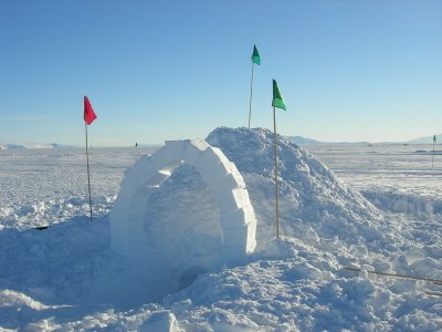
Our quinzee hut! We added the arch out of ice blocks as a fun technical challenge. Notice the fact that the entrance is below the ground surface- this is because you want the hot air you produce inside to stay inside! The lowered entrance serves as a cold air sink.

The next day we got to learn how to use the high frequency (HF) and very high frequency (VHF) radios. The HF radio is something you would see in a World War I movie. It is a huge box with wires that you stretch out in a V formation 40 feet long and then suspend them from bamboo sticks. For practice, I personally got to call the South Pole station (300 miles away) and ask their RadioOps person how cold it was (-42 C). That was pretty neat and took some getting used to. You have to yell uncomfortably loudly and use all the proper radio jargon (“over,” “clear,” etc). We ended the day by doing a white-out simulation. For this exercise, Susan and Matt handed out white 5 gallon buckets with faces drawn on them. We had to put them over our heads and rescue a pretend group member that had left the tent to go to the bathroom and couldn’t find their way back. In a whiteout, there are usually winds of 80 miles per hour or more, so you can’t hear anything either. So we couldn’t see or hear or talk…needless to say my group didn’t do so well but it was a great demonstration of how difficult the actual conditions can be!
Whiteout simulation

Tuesday, November 14, 2006

Some Local Geology

McMurdo station is located on Ross Island. Ross Island is formed by three volcanoes: Mt. Erebus (see below), Mt. Terror, and Mt. Byrd. The area in and around McMurdo station is geologically governed by these volcanoes, and all the rocks here are volcanic in origin. Mt. Erebus is a stratovolcano, meaning that its cone is composed of layers of lava as well as layers of pyroclastic (or ejected) material. The majority of the rocks you see at McMurdo station are pyroclastic bombs, or tephra. In this case, the word “bombs” denotes size; they are the largest type of pyroclastic material.
Mt. Erebus, as seen from Observation Hill
The volcano is active, so you can see the gas/steam plume rising from the top.

A pyroclastic rock found near McMurdo. The holes you see are formed by gases during formation and ejection.

Monday, November 13, 2006

Life in Antarctica- McMurdo Station

There are no native people of Antarctica. The only people here for longer than a cruise or tourism visit are those that work in science or as support staff. For scientists, there are two basic ways of life in Antarctica: those that live and work at the station, and those who live and work out in the “field.” The “field” means any location without permanent buildings and usually implies that you are camping and living with fewer resources (showers, toilets, etc). In a week I will go out to the field for the remainder of my time here, but even everyone that comes to Antarctica to work in the field has to go to one of the main stations first to get training (if it’s your first time to the ice) or collect gear. McMurdo station is the largest of the many US research stations on Antarctica, and it is located off the Ross Sea on McMurdo sound. At peak capacity in the summertime (Nov-Jan) there can be up to 1100 people living here.
Despite what you might think, station life is pretty normal. It reminds me a lot of summer camp or college because you stay in a dorm style room, you go to the dining hall for meals, there is a clinic, gym and even a church. Because so many people are down here (100-200 stay over the wintertime too) quite a lot of social activities have evolved. You can sign up for intramural sports like dodge ball and soccer, there are yoga classes every week, there is a rock climbing wall and bouldering gym, bowling alley, a ceramics room and even a local radio station. There are three bars at the station that usually host talent shows, open mic nights or parties. One guy even started a program after the US TV show called “The Biggest Loser: Antarctica” to help people lose weight! The people at McMurdo have also established some trails around the area that you can hike or ski in your free time if you’ve taken the Outdoor Safety class. You can even rent cross country skis and other outdoor gear for free.
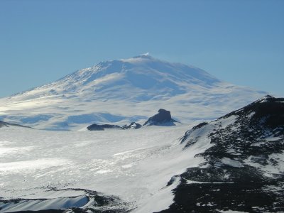
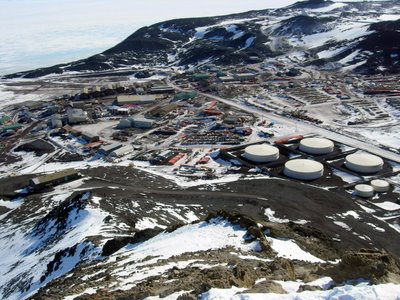
View of McMurdo Station from Observation Hill

The station itself looks pretty ugly because all the buildings are designed for function (not style) and look like warehouses from the outside. Inside though, they look like normal academic buildings and labs. At first I was surprised to learn that I’d be able to access the internet at all but I didn’t expect almost all of the station to be equipped with wireless access. Even some of the field camps have wireless access (in the trailers). I can also call home from a regular land line telephone. One important thing I have to remember when calling home- I’m 18 hours ahead of the east coast! McMurdo station keeps New Zealand time, so when it’s noon on Sunday in Maryland, it’s 8am on Monday here!

Saturday, November 11, 2006

Christchurch

The Christchurch Cathedral

Friday, November 10, 2006 8:00 AM NZ time

The last two days I have been in Christchurch, New Zealand, preparing for my flight down to Antarctica, or “the ice” as the lingo goes. There are a lot of other US Antarctic Program people in my hotel and others nearby so we have all been touring around and keeping each other company. Many of us (myself included) have never been to the ice before. We all went to get our extreme cold weather gear (ECW) at the clothing distribution center (CDC- there are a lot of abbreviations to remember) in Christchurch yesterday. One of the women that worked there told me that there is over $4 million worth of gear there. When I have all of it on, I look pretty ridiculous, but it is extremely warm.
Today is our flight to the ice. It will be in a US Air Force cargo plane (so no comfy seats for us) and will last about 5 hours assuming we don’t have to “boomerang,” which means that we’d have to turn around mid-flight because of unsafe landing conditions at McMurdo station. Despite the lack of cushy seats and flight attendants, they do treat you pretty well. The caterers already gave us a bag lunch for our flight (and somehow they knew I was vegetarian) and you get as many sets of earplugs as you could ever want. Once I get down to McMurdo station, I will spend about a week there doing snow safety school and snowmobile and helicopter training (no I don’t get to fly one) before I go out to the Dry Valleys to actually start doing fieldwork. Pretty exciting stuff.

At the Clothing Distribution Center (CDC)

Thursday, November 9, 2006

Background

Here are some details about my job: From November until February, I will be working as a research assistant in an area of Antarctica called the Dry Valleys. My job is part of a Long Term Ecological Research project, with the broad aim of collecting the same data for many years in a row in order to get a clear picture of how climate change is happening. As part of the “Stream Team,” I will be studying 19 streams in the Dry Valleys, collecting data on water quality and stream flow that can then be compared to the same data collected in years past. There are two other stream team members, Lee (a PhD student that will also be collecting her own data on stream algae) and Ray (a United States Geological Survey hydrologist that will help with technical stuff). In this forum, I will talk about everything from penguins, to life in Antarctica, to how to properly measure stream flow. Please ask me any questions you may have and depending on how busy we are, I will be able to post a reply soon.